Santa Isabel, Puerto Rico
(SAHN-tah ee-sah-BEL)
Santa Isabel is known as La Ciudad de los Potros (colts city). Santa Isabel was founded on October 5, 1842 by Antonio Vélez.
Santa Isabel is located in the southern coast, south of Coamo; east of Juana Díaz; and west of Salinas.
The surrounding areas produces fruits.
There are many well-known santaisabelinos, among them: Cesar Miranda, and Carmelo Colon Rivera.
Santa Isabel is made up of 8 barrios (PDF) (wards/districts):
- Boca Velázquez
- Descalabrado
- Felicia Uno
- Felicia Dos
- Jauca I
- Jauca II
- Playa
- Pueblo
Restaurants
- Oasis Bakery & Cafe (Puerto Rican), (787) 845-4567
- Oasis Bakery & Café (Puerto Rican), (787) 845-4567
- Regas Patio (Sea Food), (787) 845-3686
Festivals and Events
- Carnaval del Cemi - October
-
Carnaval del Juey
- June
Fresh crab dishes, cooking competitions, music.
- Festival del Mango - May
- Festival del Pavo - November
-
Fiestas Patronales de Santiago Apostol
- July
Every year, Santa Isabel celebrates a patron saint festival. The festivities include dances, food, parades and religious processions.
Displaying 5 results.
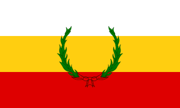
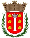
Symbols
Education
There are 11 public schools in Santa Isabel, education is handled by the Puerto Rico Department of Education.
Anthem: En un pedazo del sur estas presente...
Climate
10 Day Forecast from weather.com
Demographics *
Population
20,281
Land Area: 34.02 sq mi
Density: 630.7 per sq mi
Median Age: 39.5
Sex: 52% female
Economics **
$11,413
Median household income: $20,000
Puerto Rico: $21,058
Persons below poverty line: 48.4%
Housing, families and educational attainment *
Number of households
7,368
Housing units density:
281.5 (2013)
Persons per household: 2.91
High school grad or higher: 82.8%
Marital status: 34% married
* U.S. Census Bureau 2020 data, unless otherwise noted - Source: Quick Facts Puerto Rico.
** U.S. Census Bureau 2016-2020
Map References
Coordinates: 17.9661° N, 66.4050° W
ZIP Code: 757
Driving Distance from San Juan: 63.1 miles
Driving Time: 1 hour, 32 minutes
Did You Know?
Puerto Rico's flag was designed in 1895 but was illegal to display until 1952 under U.S. rule.
This is your comprehensive guide to La Isla del Encanto.